
About
I am currently pursuing Ph.D. degree in Marine and Coastal Environmental Science at Texas A&M University, Galveston, Texas, USA. I was previously employed at Geoinformatics Center - Asian Institute of Technology (GIC-AIT) in Thailand. Skilled and experienced disaster risk reduction specialist with a background in modeling natural hazards and multi-hazard risk assessment. Proficient in using GIS software and technologies to create detailed maps and spatial data visualizations. Strong analytical skills and ability to interpret and analyze geospatial data for decision-making. Proven ability to work with cross-disciplinary teams and deliver project outcomes on time. Experience in various domains including disaster risk management, natural resource management and nature-based solutions. Strong communicator with excellent presentation and report-writing skills.
Geospatial & Natural Hazards Researcher
- Website: www.shakya-anish.com.np
- Current City: Galveston, USA
- Degree: currently Ph.D. student
- Email:
shakya.anice@gmail.com
anish_shakya@tamu.edu
Skills
- GIS and Earth Observation: ArcGIS Pro, ArcMap, ArcGIS Online, ArcGIS Maps for Adobe, QGIS, ERDAS
- Programming/Scripting: Python, Git, Google Earth Engine
- Modelling: ILWIS, OpenLISEM Hazard, InVEST, HEC-RAS, Flow-R, SCOOPS-3D
- Statistical: STATA
- Illustration: Adobe Illustrator, Blender
- Microsoft Package: Word, Excel, Powerpoint
Resume
Summary
Anish Ratna Shakya
Skilled and experienced in disaster risk reduction with strong background in natural hazard modelling and multi-hazard risk assessment. Interested in multi-hazard interactions research, risk and resilience, anticipatory actions and socio-economic impacts of disaster. .
Education
Ph.D. in Marine & Coastal Environmental Science
2024 - present
Texas A & M University, Galveston, USA
Modules included: Cores of GIS and Remote Sensing, Quantitative Resource Management Methods, Coastal Hazards and Resiliency Environmental Conflict Resolution, Research Methods, Coastal Modelling.
Master of Geoinformation Science & Earth Observation
2018 - 2020
ITC, University of Twente, Enschede, The Netherlands
Division: Distinction – Cum Laude (CGPA: 8.37 out of 10)
Modules included: Cores of GIS and Remote Sensing, Introduction to natural hazards and risk, natural hazard modelling, Physically based hazard modeling, UAV for Earth Observation, Multi-hazard risk assessment, Catchment hydrology and surface water.
Bachelor of Environmental Science
2012 - 2016
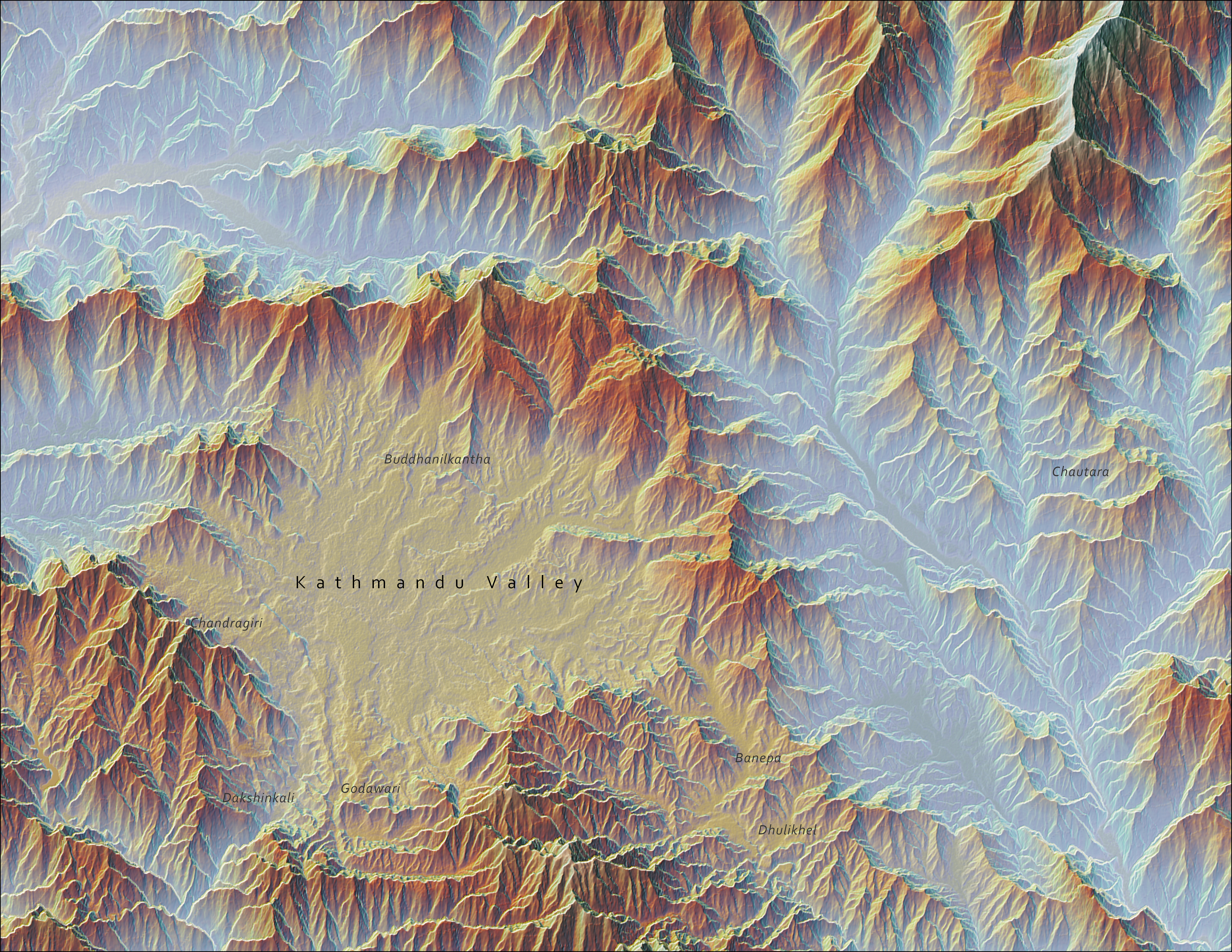
Kathmandu University, Dhulikhel, Nepal
Division: Distinction (CGPA: 3.88 out of 4)
Modules included: Professional and research skills for environmental specialization, Environmental impact assessment, Environmental hazards and disaster management, Municipal and hazard waste management, GIS and remote sensing, Integrated watershed management, Instrumental and quantitative analysis, Conservation biology and Aquatic ecology.
Professional Experience
Senior Research Associate
Feb 2021 - Jul 2024
Geoinformatics Center - Asian Institute of Technology, Pathum Thani, Thailand
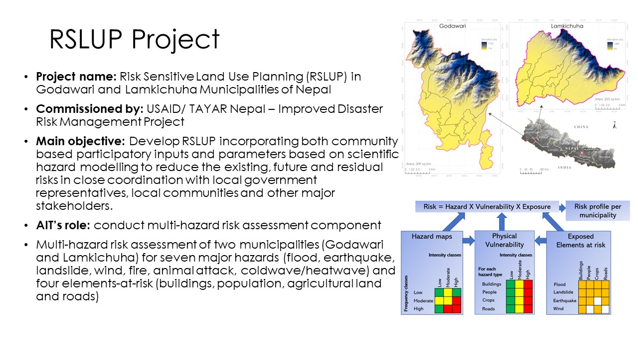
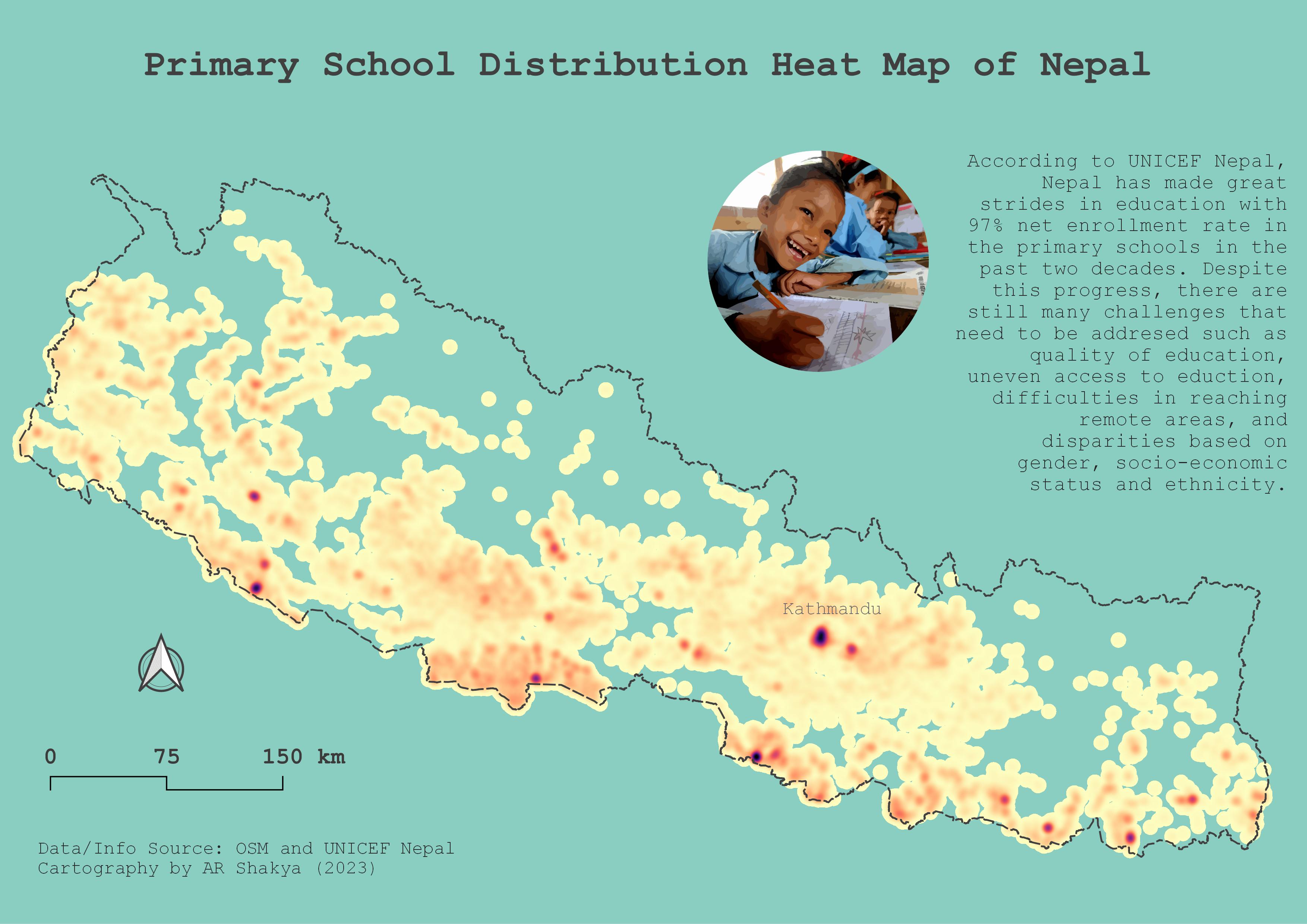
- Accomplished the multi-hazard risk assessment project in two municipalities of Nepal.
- Modeled natural hazards using physically based and statistical models for various projects.
- Assessed the multi-hazard vulnerability, loss and risk for different elements-at-risks.
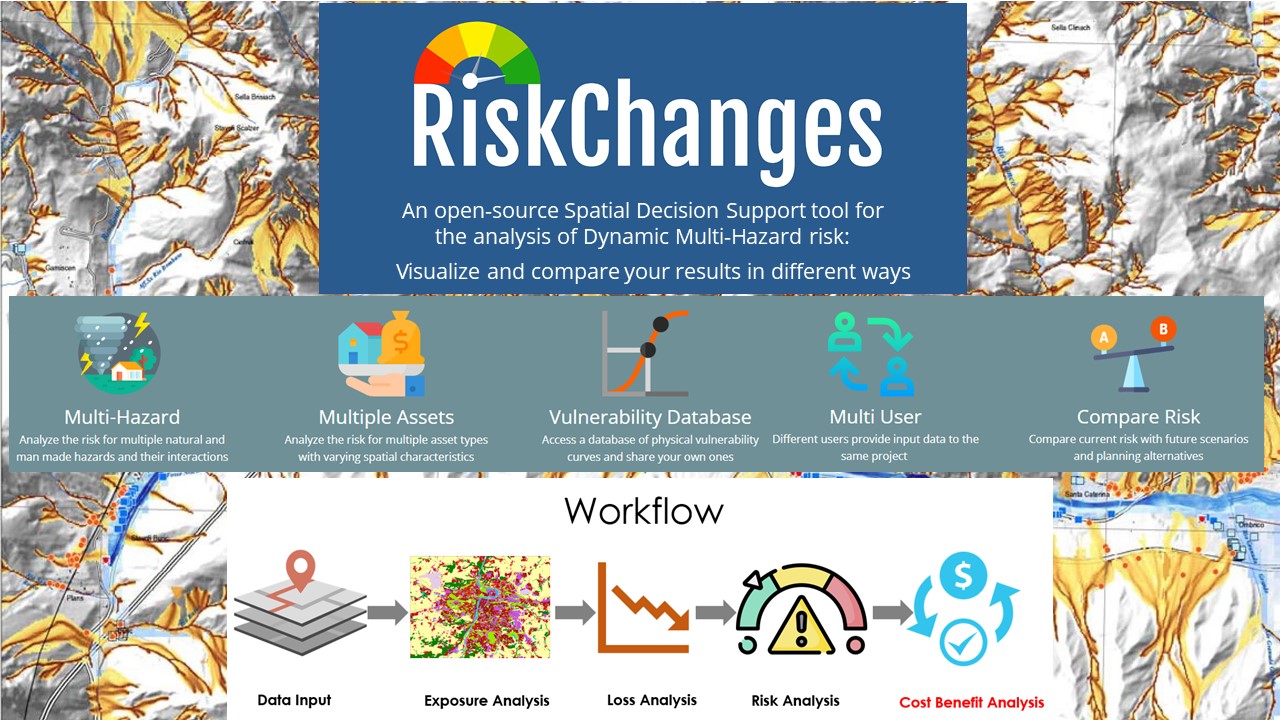
- Tested and documented the bugs for the Guided User Interface (GUI) version of the home built multi-hazard risk analysis tool called RiskChanges
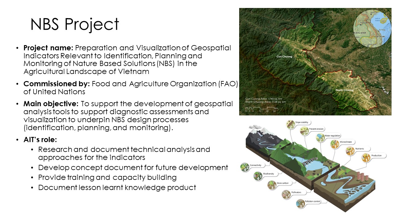
- Conceptualized the diagnostic indicators for application of nature-based solutions in agricultural landscape.
- Trained the delegates of governmental agencies about digital technologies on disaster risk management in Mongolia, Nepal, Sri Lanka and Bhutan.
Environmental Associate
Aug 2017 - Jul 2018
Lalitpur Metropolitan City Office, Lalitpur, Nepal
- Trained the communities about occupational health and solid waste management.
- Mapped and digitized the geospatial information associated with solid waste management.
- Operated the Management Information System (MIS) related to solid waste management.
- Conceptualized the environmental quality studies, protocols, and standards.
- Authored several technical reports.Developed numerous marketing programs (logos, brochures,infographics, presentations, and advertisements).

Contact
Location:
200 Seawolf Pkwy, Galveston, TX 77554
Email:
shakya.anice@gmail.com | anish_shakya@tamu.edu